my iPhone's been secretly recording every place i've been for the last year...

And impressively, all without GPS. What you're seeing is cell tower data, stored locally on my laptop when i backup my phone. The software locates your phone's backup files & displays it's location history. Pretty creepy. And yeah, kinda beautiful at the same time.

Screen_shot_2011-04-20_at_10

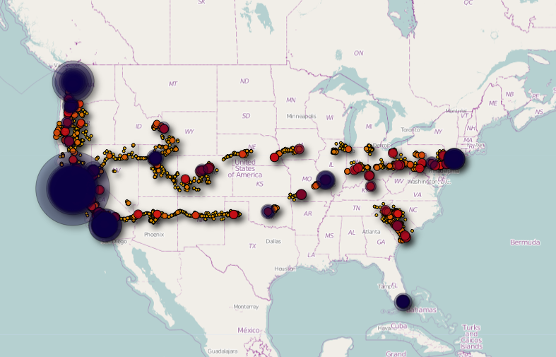
Zooming in closer to San Fransico, you can see how accurate it is with all the tiny trails mapping hundreds of photo excusions.

Screen_shot_2011-04-20_at_10

if you're on a Mac, track yourself with iPhone Tracker: http://petewarden.github.com/iPhoneTracker/

the following photos document the events that occurred between 11:00am & 7:16pm on Saturday, April 2, 2011.

1e09af57e4154362b20618c8262afb44_7

11:00 am - Multnomah Falls as seen though the Hasselblad.


38f44908768249709c03864d5f8ccb0d_7

2:00 pm - Found a view of the Columbia River Gorge


A8209415079d43c1a598fadfaaa2e3dd_7

5:36 pm - Almost went off the road in a snow storm on Mt. Hood


Bf096c637b1e476d8f533a47f31c807d_7

6:30 pm - The snow disappeared.


496c688f1f5f4a05a653007b0e1a62f3_7

7:00 pm - Snuck onto an airfield to watch the sun set behind a lone Lockheed Electra.


Instagram-rise2

7:16 pm - Finished a roll of 120 film with an abandoned house in Madras, Oregon.


as seen by my phone.